There is not just one answer on how to handle forests in WAsP. How you should model a forest depends on many different factors: type of forest, porosity, density, extent of the forested area and so on. Further, is the met. mast/turbine site inside the forest, close to the edge or far from the forest? These are important considerations that you will have to take into account for each specific site/forest situation.
Far from the forest …
If the met. mast or turbine site is located far from the forest, you should simply specify the roughness length value (z0) of the forest in the WAsP map, i.e. similar to the way you would specify any other roughness area.
Estimating the roughness length can be done following the recommendations of the “Table of roughness lengths” in the WAsP help file. However, it should be kept in mind that the forest roughness depends on the density and other characteristics of the forest.
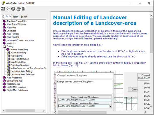
In WAsP, the roughness length of the forest (as well as any other roughness area) is taken into account by inserting the WAsP map. The WAsP Map Editor makes it possible to create, edit, save and open WAsP maps. For more information, please refer to the WAsP Map Editor help file, e.g. regarding “Manual Editing of Landcover description of a Landcover-area”.
Within or near the forest …
If the met. mast or turbine site is located within or near the forest, the effective height of the anemometer or wind turbine hub is less than the nominal height. This is due to the fact that the entire airflow has been lifted somewhat because of the forest. The height of this new reference level is called the zero plane displacement height (d). In this case, you should also specify the zero plane displacement height of the forest in the WAsP map.
The zero plane displacement height depends on the mean height of the roughness elements/canopy (trees), the density of the forest and even slightly on the wind speed. The ratio of zero plane displacement height to height of the forest (canopy) is often given as about 2/3. However, it should be kept in mind that the zero plane displacement height also depends on the density and other characteristics of the forest.
In WAsP, the zero plane displacement height is taken into account by inserting a WAsP GML land cover map, which includes the displacement height (as well as the roughness length of the forest). The WAsP Map Editor makes it possible to create, edit, save and open WAsP GML land cover maps. For more information, please refer to the WAsP Map Editor help file, e.g. regarding “Manual Editing of Landcover description of a Landcover-area”.
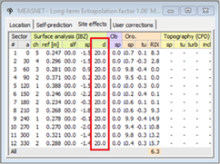
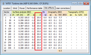
When inserting a WAsP GML land cover map, which includes one or more displacement heights, WAsP uses the wind flow model to assess the sector-wise displacement heights at any site.
Subsequently, WAsP uses the wind flow model and applies the displacement heights in calculations of generalised wind climates as well as predicted wind climates.
Compared to WAsP 12.6 and earlier versions, the wind flow model includes a) modifications to the roughness submodule and b) modifications to the orographic submodule.
Re. the roughness submodule:
Previous versions of WAsP use an algorithm, which finds all crossings between the roughness change lines defined in a WAsP map and a number of rays extending from the point of interest. In WAsP 12.7 and newer versions, we also take into account the effect of displacement height, d. This information has to be passed from the land cover contour lines to the roughness model. So, instead of each line in the WAsP GML land cover map containing a left- and right roughness length, z0 , the new routines expect the input of ’identifier’ lines, i.e. each line contains an identifier (ID), which represents a certain land cover left and right of the line. This ID is then represented in a land cover table, which prescribes the corresponding z0, d and a description of that land cover class.
A new spider grid analysis routine processes WAsP GML land cover maps. It uses a polar zooming grid, similarly to the orographic flow model (Troen, 1990). For each cell in the zooming grid, the fraction of the total area, fi, that each of a total of N land cover types in the land cover table occupies is determined and the roughness length is calculated. The displacement height is taken into account similarly to z0 and is calculated for each cell in the zooming grid.
Re. the orographic submodule:
The submodule for orography computes speed-ups due to elevation, and WAsP uses the Bessel-expansion on a zooming grid (BZ) model (Troen, 1990). The input of the orographic model is a WAsP GML elevation map, which is processed into a polar zooming grid, with the highest resolution at the center point of the grid. The zooming grid of d obtained by using the spider grid analysis routine is added to the terrain elevation zooming grid. Using this grid, the methodology described in Troen (1990) is used to calculate sector-wise orographic speed-ups. In a forest, the introduction of a displacement height can cause orographic speed-ups to be different, although the input elevation data are the same.
For more information about the improved wind flow model, please refer to the paper “Satellite-based estimation of roughness lengths and displacement heights for wind resource modelling”.
For more information about roughness and zero-plane displacement height, please refer to the paper “WAsP in the forest”.
References
Rogier Floors, Merete Badger, Ib Troen, Kenneth Grogan, and Finn-Hendrik Permien: “Satellite-based estimation of roughness lengths and displacement heights for wind resource modelling”, Wind Energy Science, 6, 1379–1400, https://doi.org/10.5194/wes-6-1379-2021, 2021.
Ebba Dellwik, Lars Landberg and Niels Otto Jensen. “WAsP in the forest”, Scientific Proceedings, European Wind Energy Conference and Exhibition 2004, London, England, 22-25 November.