The Site effects tab of met. stations and turbine sites has a column "Reference [m]" under the header "Roughness": it contains reference roughness lengths for the different directional sectors (framed green in the picture below)
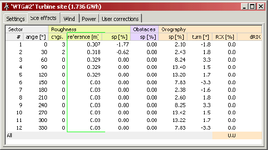
For a certain site of interest the reference roughness is the "distant terrain roughness" or the meso-scale roughness in the direction of the sector in question. It is used as basis when calculating the effects (speed-up and turning) of the different terrain features. A roughness speed-up of, say, 5%, means that for the sector in question the actual terrain roughness distribution gives an increase of the wind speed of 5% as compared to a terrain with constant roughness equal to the reference roughness.
As roughnesses beyond a certain equilibrium distance has no effect on the wind at a site of interest, the reference roughness includes mainly the terrain roughnesses within that equilibrium distance (about 10 km). Roughnesses beyond the equilibrium distance is allowed only to be included with a very small weight, a weight which is decreasing with distance.
Details in the calculation of the reference roughness is described in section 8.3 of the European Wind Atlas.