In WAsP 12.8, we introduce an improved stability model, which uses stability inputs derived from ERA5 to account for local atmospheric stability conditions anywhere in the world. Specifically:
- The T-star stability model uses sector-wise stability inputs derived from ERA5 as well as sector-wise geostrophic shear inputs also derived from ERA5
- Validations show that the T-star stability model gives improved wind flow modelling and reduced cross prediction errors
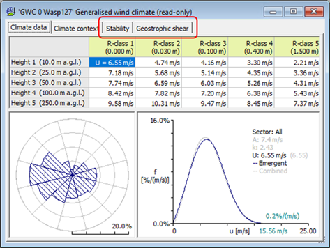
In the Generalised Wind Climate window, there are two new tabs for “Stability” and “Geostrophic shear” (replacing the old tab for “Profile model”).
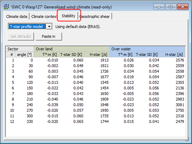
In the “Stability” tab, it is possible to select either the T-star stability model or the classic EWA (European Wind Atlas) stability model, and this tab also shows the data/values for the selected profile model. For the T-star stability model, the button “Get defaults” automatically retrieves and inserts the default data for each wind direction sector.
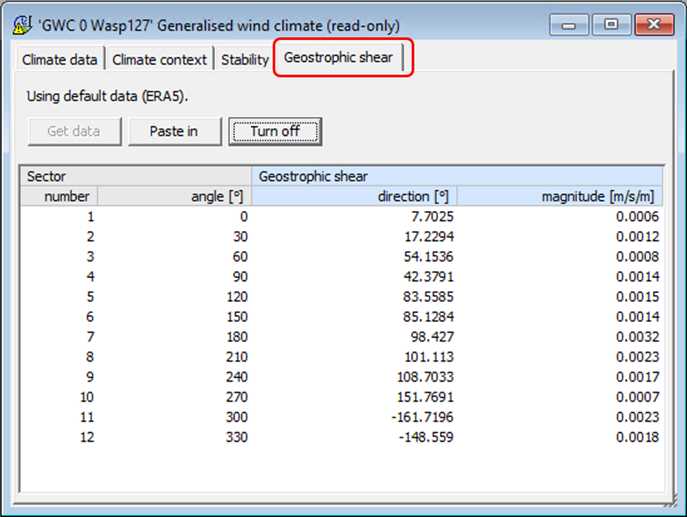
The “Geostrophic shear” tab shows the data/values, and the button “Get data” automatically retrieves and inserts the default data for each wind direction sector. There is also a button to turn off the geostrophic shear model by zeroing all the values.
The T-star stability model has been thoroughly validated against wind measurements from six sites in northwestern Europe [1]. The results show that using WAsP 12.8 with the T-star stability model and default settings (including default stability data derived from ERA5) gives improved wind flow modelling when comparing to the results using WAsP 12.7 with the classic EWA stability model and default settings.
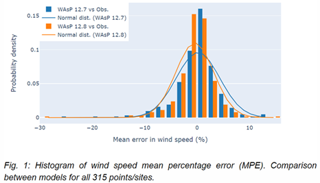
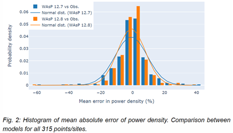
Furthermore, the T-star stability model has been validated against wind measurements from 109 masts, which are located across four continents and in many different climate zones. Using WAsP 12.8 with the T-star stability model and default settings (including default stability data derived from ERA5) results in reduced cross prediction errors of 1) mean wind speeds and 2) mean wind power densities.
Importantly:
-
The mean absolute cross prediction error of the 109 mean wind speeds is reduced from 2.9% for WAsP 12.7 to 2.3% for WAsP 12.8.
-
The mean absolute cross prediction error of the 109 mean wind power densities is reduced from 6.8% for WAsP 12.7 to 5.5% for WAsP 12.8.
For more information about the improved stability model, please refer to the paper “Using observed and modelled heat fluxes for improved extrapolation of wind distributions” [1]. The validation report for all 109 masts is also available [2].
WAsP Map Editor 12.4
The WAsP Map Editor 12.4 has recently been improved with some extended features and bug fixes.
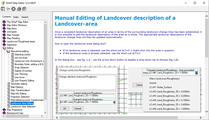
The land cover concept is now fully introduced, allowing advanced description of terrain surfaces, like “Roughness_and_Displacement”. Thus, maps with advanced land cover features may be opened or imported, or you may add advanced land cover features to an existing map by digitizing and editing in much the same way as you would digitize and edit a classic roughness feature.
For more information about the land cover concept, please refer to the WAsP Map Editor help file, e.g. regarding “Manual Editing of Land cover description of a Land cover-area”.
The new GML file format is now also fully introduced. It has two variants; one for orography/elevation (extension .oro.gml) and one for land cover information, including roughness and displacement height (extension .lcv.gml). Please notice that in order to save advanced land cover features in a map, you must use the land cover GML file format. For more information about the new GML file format, please refer to the WAsP Map Editor help file regarding “GML map file format”.
Orography/elevation and land cover maps can be imported from the Global Wind Atlas database (GWA Map Warehouse). The land cover maps may be imported as roughness maps, i.e. the land cover categories are converted to roughness lengths during the import, using a built-in look-up table. Alternatively, when using the land cover option, the land cover description will just contain the land cover category-index of the appropriate database, e.g. CORINE(5) when using the Corine-database.
You can download the WAsP suite installer and get the release notes here: https://www.wasp.dk/Download/WAsP12-Suite-Installer.
[1] Rogier Floors, Alfredo Peña, and Ib Troen: “Using observed and modelled heat fluxes for improved extrapolation of wind distributions”, Preprint is Under Revision at Boundary-Layer Meteorology, https://www.researchsquare.com/article/rs-2123364/v1
[2] https://www.wasptechnical.dk/forum/topic/687-validation-report-wasp128/