In WAsP 12.9 we introduce automatic import of vector maps (orography and/or roughness data layers) from the Global Wind Atlas. When inserting a vector map from the Global Wind Atlas, WAsP uses the positions and heights of met stations, turbine sites, reference sites and resource grids to calculate the extent of the vector map, in accordance with the WAsP best practices.
We have decided to add this new feature to provide easy and correct access for WAsP users to orography/roughness data from the Global Wind Atlas. Inserting a map from the Global Wind Atlas can be useful for preliminary calculations, e.g. together with a single or multiple Generalised Wind Climate files from the Global Wind Atlas, ref. below.
Procedure:
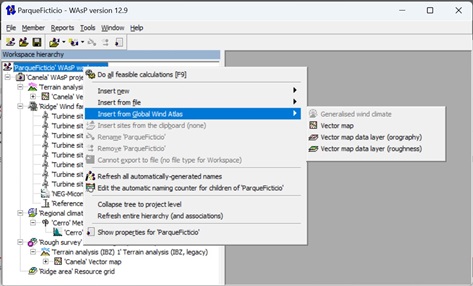
- Right-click on the workspace, project or terrain analysis and select “Insert from Global Wind Atlas”.
- Select “Vector map”, “Vector map data layer (orography)” or “Vector map data layer (roughness)”.
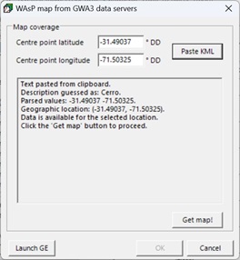
- In the following dialogue, you have two options:
- Type the centre point latitude/longitude in decimal degrees or
- Click on the button “Paste KML” to specify the centre point latitude/longitude (for this second option, you need to first open Google Earth, right-click on a placemark and select “Copy”).
![]()
![]()
If you want to insert a vector map from the Global Wind Atlas to anywhere other than a workspace or a project, then you need to manually insert a terrain analysis first. But in the project context, the terrain analysis and vector map objects are added automatically for you.
Please note that vector maps from the Global Wind Atlas are associated with varying accuracy and uncertainty, ref. Global Wind Atlas Datasets. Therefore, vector maps from the Global Wind Atlas should be used to perform preliminary calculations only – especially in areas with complex terrain.
WAsP 12.9 also includes an improvement of the existing automatic import of Generalised Wind Climate (GWC) files from the Global Wind Atlas. Therefore, it is now also possible for the WAsP user to quickly and easily insert individual GWCs for each turbine site and/or reference site (in addition to the already existing possibility to insert a single GWC for turbine sites, reference sites and resource grids).
We have decided to add this new feature because it is useful in cases where a single GWC is not representative of multiple sites, and this happens when there are mesoscale and/or large-scale effects across the modelled area (because these effects are not included in the WAsP IBZ/CFD microscale flow models).
Procedure:
- Right-click on the workspace or any project, wind farm or turbine cluster and select “Insert from Global Wind Atlas”.
- Select “Generalised wind climate”.
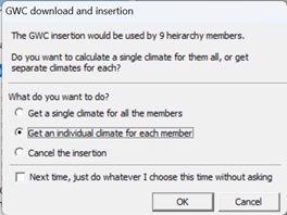
- In the following dialogue, select “Get an individual climate for each member”.

Please note that wind climate data from the Global Wind Atlas are associated with varying accuracy and uncertainty, ref. Global Wind Atlas Validation. Therefore, wind climate data from the Global Wind Atlas should be used to perform preliminary calculations only – especially in areas with complex terrain.
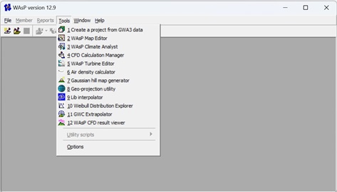
WAsP 12.9 also includes a new tool to “Create a project from GWA3 data”.
In a matter of a few seconds, the new tool can create a WAsP project, which includes the following GWA3 data:
- One vector map, including orography and roughness data layers as well as a note with a description of the data
- One Generalised Wind Climate file, interpolated for the centre point of the vector map
- One wind turbine site, located at the centre point of the vector map (for each of three IEC classes of 3.45 MW wind turbines)
Procedure:
- You will find the new tool in the "Tools" dropdown menu.
- In the following dialogue, you have two options:
- Type the centre point latitude/longitude in decimal degrees or
- Click on the button “Paste KML” to specify the centre point latitude/longitude (for this second option, you need to first open Google Earth, right-click on a placemark and select “Copy”).
Please note that GWA3 data are associated with varying accuracy and uncertainty. Therefore, GWA3 data should be used to perform preliminary calculations only – especially in areas with complex terrain.
You are requested to use the main reference for the Global Wind Atlas, by including the following text:
“Neil N. Davis, Jake Badger, Andrea N. Hahmann, Brian O. Hansen, Niels G. Mortensen, Mark Kelly, Xiaoli G. Larsén, Bjarke T. Olsen, Rogier Floors, Gil Lizcano, Pau Casso, Oriol Lacave, Albert Bosch, Ides Bauwens, Oliver James Knight, Albertine Potter van Loon, Rachel Fox, Tigran Parvanyan, Søren Bo Krohn Hansen, Duncan Heathfield, Marko Onninen, Ray Drummond; The Global Wind Atlas: A high-resolution dataset of climatologies and associated web-based application; Bulletin of the American Meteorological Society, Volume 104: Issue 8, Pages E1507-E1525, August 2023, DOI: https://doi.org/10.1175/BAMS-D-21-0075.1”
Furthermore, you are requested to provide attribution to recognize the full partnership involved in developing the GWA App and Works, by including the following text:
“[Data/information/map] obtained from the Global Wind Atlas version 3.3, a free, web-based application developed, owned and operated by the Technical University of Denmark (DTU). The Global Wind Atlas version 3.3 is released in partnership with the World Bank Group, utilizing data provided by Vortex, using funding provided by the Energy Sector Management Assistance Program (ESMAP). For additional information: https://globalwindatlas.info”
You can download the WAsP Suite installer and get the release notes here:
https://www.wasp.dk/download