WAsP 12.10.18 (Suite release 2025-A-11)
- Shelter model has been completely overhauled:
- Some geometric bugs fixed
- Roughness treatment improved
- Update to the normalised drag coefficient
- Wind flow within an obstacle is now zero
- If you have previously used the shelter model in a calculation, we recommend that you experiment with recalculation. There should be only small difference in the site corrections, but it’s important to check the consequence end-to-end in the calculation
- Handles maps with the UK (OSGB) projection correctly
- Some minor bug fixes:
- Fixed occasional problems with rated power estimation
- Fixed occasional overflow errors with CFD tile import
- Extend map sizes for offshore sites before calling WAT
WAsP 12.09.34 (Suite release 2024-A-11)
- Handles larger maps when saving workspaces (fixing out of memory error)
- Locates turbine site at the requested centre point when using the WAsP tool Create a project from GWA3 data
- Handles maps with the SWEREF 99 projection correctly
WAsP 12.09.10 (Suite release 2024-A-2)
- New automatic import of vector maps (orography and/or roughness data layers) from the Global Wind Atlas
- Improved automatic import of GWC files from the Global Wind Atlas
- New tool to “Create a project from GWA3 data”
- Fixes capacity factor display from resource grids in Google Earth
- Lowest RIX threshold slope is now 0.01 (because of new German standard)
- *.pow format wind turbine generator files can now be opened properly in WAsP 12
- Gauss-Krüger projection should work more reliably
- GWCs can be exported as legacy LIB format in some cases
- Various minor bug fixes
WAsP 12.8.32 (Suite release 2023-A-8)
- WAsP Engineering can again export files for WAT
- Out of memory errors for extremely large resource grids are now correctly described
- Program no longer stalls for a couple of seconds when a GWC window is first opened
- Scripts are now fully adjusted to work with new GWC format
- The GWC extrapolator utility program works again
WAsP 12.8.22 (Suite release 2023-A-3)
Map files containing only one type of spatial data can now be inserted as children of vector map hierarchy members.
WAsP 12.8.20 (Suite release 2023-A-2)
Fix to the site effects table when displaying CFD flow model results. The speed effects were not showing.
WAsP 12.8.18 (Suite release 2023-A-1)
- New stability model option
- In addition to the ‘classic’ European Wind Atlas profile model, a new ‘T-star’ profile model is introduced
- T-star is data-driven, using 6 sector-wise variables to describe the heat flux and boundary layer.
- Data are provided with global coverage, derived from ERA5 reanalysis.
- New geostrophic shear vector data
- Direction-dependent data replace the all-sector data introduced in an earlier version of WAsP 12.
- Data are provided with global coverage, derived from ERA5 reanalysis.
- Generalised wind climate standard conditions (roughness lengths, heights) can now be edited directly: no need to change project parameters and recreate.
Release 2022-A-10
This update fixes a problem caused by a recent update to the .NET framework which prevented WAsP software from running.
Release 2022-A-7
Fixes a problem with saving map files to the CFD job requests.
Release 2022-A-6
Bug fix with the total capacity factor calculation for wind farms, and various other minor issues and updates.
Release 2022-A-3
Fixes a problem for WAsP 11 which was introduced in the previous release.
Release 2022-A-2
Fixes a problem for WAsP 11 which was introduced in the previous release.
Release 2022-A-1
- Roughness and displacement changes
- Zero plane displacement is accepted as spatial data input (alongside roughness length)
- Aerodynamic roughness length analysis model is fully revised
- Displacement heights affect orographic flow corrections
- Directional site displacement height is coherently used in wind calculations
- Round-trip editing of land cover GML maps is now possible
- New example workspaces are included
- Updated Help file
- Bug fixes
- Far offshore elevation can be non-zero
- Map projections not reliably stored and restored in workspace file
- Large vector map files slow to open from disk
- Resource grid structure copy-paste from clipboard not working
- Wind rose displays pop-up labels not displaying correctly on mouseover
- Too many files left in temporary folder after WAsP shutdown
Release 2021-A-8
Performance improvement when CFD result files contain huge maps’
Release 2021-A-6
Fixing bug which prevented insertion of turbine sites from clipboard or file
Release 2021-A-5
Bug fix in wind farm capacity factor calculations.
Release 2021-A-4
Fixes an occasional problem for WindPro users when calculating resource grids.
WAsP 12.6.22, Release A
- Climate data from the Global Wind Atlas can be automatically imported from a new online data service.
- A new site similarity report (script) calculates dissimilarities between met. station and sites, including speed-up dissimilarities according to a new method developed by DTU.
- Barometric reference data set is updated using ERA5 data 2010-2020.
- Air density calculation uses variable temperature lapse rate.
- Updated Help file
WAsP 12.5.10, Release B
Minor bug fixes
WAsP 12.5.8, Release A
Wind turbine generator control systems can be set explicitly
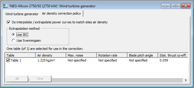
Pitch or stall control system choice (in wtg file) is now used in air density correction of power curve.
Automatic inference of control system is offered if control system is not specified (in wtg file).
Capacity factor results
Rated power is now explicitly required for all WTGs (in wtg files).
Capacity factor can be calculated for turbine sites, site groups, wind farms and resource grids.
Capacity factors are included in output reports.
New WAsP CFD result viewer
WAsP CFD result files (cfdres files) can be opened, viewed and explored in a new “WAsP CFD result viewer”, which is available in the “Tools” menu.
Miscellaneous changes and fixes
Maps with many lines can be opened.
On-disk edits to hierarchy members at the workspace root now also prompt automatic re-import.
Added air density to the turbine site list of the wind farm window.
Fixed for the AEP rose display where toggling PD view with a sector selected.
Improved error messages relating to climate members.
WAsP 12.4, Release C
Bug fixes
• Various problems with resource grid masking are corrected in WAsP.
• WAsP 11 can now open the updated WTG file format used by recent WAsP 12 releases.
• WACA 3 now works properly on Japanese language Windows 10 operating systems.
WAsP 12.4.38 Release B
Requirement for equal static thrust coefficients relaxed
In connection with air density correction of power curves, the requirement for equal static thrust coefficients at different air densities has been relaxed. So now, power curves with different static thrust coefficients can be used for air density correction (interpolation) of power curves.
WAsP 12.4.34 Release A
Separate treatment of data layers in vector map
Vector map data layer of roughness, elevation and boundaries are now separately presented in the project hierarchy, making it easy to swap different layers in and out of the modelling context.
WTG file format update
Extended new properties supported by the wind turbine generator file format are now displayed in the user interface. These properties are rated power and control system. The control system choice will be used for power curve adaptation calculations in a future release.
Bug fixes
-
Wind atlases with no barometric data now show as ‘cannot calculate’
-
Reliability improvements to automatic fill-out of location and barometric reference data to older atlases.
-
Restored ability to export WAsP 12 workspaces to WAsP 11 format
WAsP 12.3.18 Release B
• Map parsing no longer fails with ”out of memory” error for one map.
• Calculation no longer fails for a turbine site, if the wind atlas is moved to hierarchy root and 'DoAllCalculations' is invoked
• Wind atlas in hierarchy is now displayed as 'bad' (red icon) if missing barometric data makes it impossible to calculate
• Now a proper icon for a wind atlas is displayed if it is adjusted, calculating and in the workspace root.
• If there is no wind, f / vs U label is no longer displayed in turbine site (also maybe ref site) graphics.
• Trying to let WAsP auto fill baro data for old atlases should now proceed without prpoblems.
• We have extended the WTG file format to accommodate extra data: rated power, control system (pithc/stall regulation), though these are still not displayed and used in the power curve corrections.
• The turbine editor has been updated, now letting you specify rated power and control system.
WAsP 12.3, Release A
Wake-reduced mean speed
This is now calculated for each sector of each turbine in a wind farm. The results are shown alongside the wake-free mean wind speed in the turbine site window and in the wind farm results.
Wind speed contribution rose in reference site and turbine site windows
In addition to the simple sector frequency, the sector contribution to the total mean speed for a site can now be illustrated in the turbine site and reference site windows’ predicted wind climate graphics.
Miscellaneous changes
• Added air density to the turbine site list of the wind farm window.
• Fixed for the AEP rose display where toggling PD view with a sector selected.
WAsP Version 12.2.32, Release B
New features
• Semi-automatic retrieval of barometric reference data for older generalised wind climates.
• Each turbine site window now displays the corrected WTG performance table for that site.
• Turbine site full-precision report now includes the corrected performance table in results.
• Weibull Explorer tool is back.
• New script gives full-precision output report for reference sites.
• Geographical locations now displayed in both decimal and DMS format.
• Generalised wind climate profile configuration data grid can now be copied to clipboard.
• New sanity limits imposed on Weibull A and k parameters (100 m/s and 20, respectively).
• Wind farm scripts now refuse to run on turbine site sub-groups and display a message.
Bug fixes
• Park model (1 & 2) can now handle large wind farms of more than 200 turbines.
• Removed redundant extra stage of wake calculations for park power curve.
• WTG window now supports copy to clipboard again.
• Restore all defaults in wake decay coefficients now working properly.
• Barometric data is now available for locations with longitudes between -1 and 0.
• CFD calculation with map containing unusual characters in name now works.
• Minor typos corrected in turbine site window and map projection window.
• Elevation masking in resource grid masking window now works correctly again.
• DMS longitude formatting for negative values close to zero are now labelled ‘W’.
• Spatial image paste-in now working again.
• Resource grid colour scale bounds in KML now correctly coordinated.
• Generalised wind climate window clears ‘No data’ label when data generated.
• Now can change from CFD to IBZ while a turbine site window is open without error.
• Turbine sites clear calculation dirty status when recalculated following met. station removal.
Version 12.2.14, Release A
New features
• WAsP can use map files in new GML format, e.g. created using the WAsP Map Editor version 12.2
(note that separate orography and roughness map files are needed for the new GML map file format)
• Faster map file reading of map files in traditional WAsP map format
• Progress indication for map file read and write operations
• Various minor improvements
• GML application schema
Bug fixes
• Various bug fixes
Version 12.1, Release C
- Fixed: *.lib files added to a workspace may not be correctly saved and may require re-import when workspace is reopened
- Fixed: *.TAB files exported from WAsP 5 don’t open
- Fixed: wind turbine generator data grid copy to clipboard is not working
Version 12.1, Release B2
- Fixes a file export bug, which prevented proper use from WindPro
Version 12.01.0038, Release B
- WAsP Map Editor version 12 now launched from the WAsP tools menu as ’Map editor’
- CFD terrain analysis window now opens correctly
- Legacy file format export options now available for resource grids and wind farms
- Three old scripts updated from WAsP 11 and working again
- New report script offering full-precision results as ASCII for a turbine site
- Wind atlas report now works even if atlas is not in a project
- OWC Wizard is now removed from the tools menu
- WTG files with no release date are now opened without error
Version 12.01.0032, Release A
- Location-dependent geostrophic wind shear effects included in GWC climate calculations
- Wind farms and resource grids can again be exported to legacy file formats
- WTG files with missing release date information are now handled safely
- Embedded geographical coordinates in LIB file headers are correctly parsed to estimate GWC location
Version 12.0.0.128, Release B2
Version 12.0.0.128, Release B
- Fixed problem with dragging and drawing resource grids in resource grid edit mode
- Minor fixes and updates to existing scripts
- WTG files now will not be opened if they contain CT values > 1.0
- Minor corrections to the user interface windows of turbine sites and WTGs
- Geographic location info is now embedded to GWCs when exported to legacy wind atlas format (*.lib)
- More WAsP 11 utility scripts updated to work with WAsP 12:
- Turbine site vertical profile
- Turbine site vertical profile (Excel)
- Turbine site results to RSF
- Turbine site report (Note)
- Turbine site report (ASCII)
- Custom wind farm output to file (per sector)
- Export predicted wind climate to file
Version 12.0.112, Release A
In WAsP 12 we introduce automatic calculation of site-specific air density, as well as automatic air density correction of power curves.
Based on the geographic location of the site, WAsP 12 applies barometric reference information (from CFSR reanalysis data) and the on-site elevation variations of the terrain to estimate the mean air density across the site — and specifically at the hub height of each wind turbine.
Subsequently, WAsP 12 uses the estimated air densities at the hub height of each wind turbine to interpolate between, or extrapolate from, the power curve(s) specified in the wind turbine generator file. For power curve extrapolation, WAsP 12 offers to use either the IEC extrapolation method (as described in the international standard IEC 61400-12-1) or the Svenningsen extrapolation method (adjusted IEC extrapolation method, improved to match turbine control).
More information about the Svenningsen extrapolation method can be found in the abstract/poster “Proposal of an Improved Power Curve Correction”, presented by Lasse Svenningsen (EMD International A/S) at the European Wind Energy Conference & Exhibition 2010 in Warsaw.
WAsP 12 also includes a revised version of the PARK wake model.
In the revised PARK model (PARK2), we introduce a consistent formulation for the wind speed deficit in the wakes. In addition, a more physically based linear superposition rule is introduced. Moreover, for aerodynamic reasons, wake reflection from the terrain surface is omitted. For reference, the old PARK model (PARK1) is also included in WAsP 12.
For offshore conditions, the PARK2 model has been evaluated and calibrated against a number of data sets of actual power production from offshore wind farms. The calibration resulted in a recommended/default value for the wake decay constant. With this wake decay constant, PARK2 was found to produce calculations closer to actual power productions of the offshore wind farms. Therefore, DTU Wind Energy recommends the use of PARK2 with this new default wake decay constant for offshore calculations.
For onshore conditions, actual power production data from large wind farms were not available to us. Consequently, for onshore conditions PARK2 has been calibrated against PARK1 calculations of annual energy production in order to determine a recommended/default value for the wake decay constant.
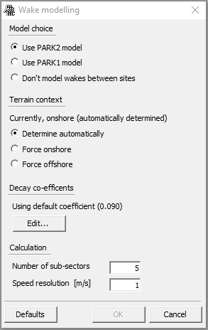
More detailed information about the revised version of the PARK model can be found in the paper “Validation of the revised PARK model”, presented by Ole S. Rathmann (DTU Wind Energy) and others at the WindEurope Conference & Exhibition 2017 in Amsterdam.
With release of WAsP 12 we have switched to a WAsP Bundle license, which is now sold by a EUR 650 annual subscription fee.
For new subscribers, there is an additional EUR 1300 signup fee. However, signup is free for WAsP 11 and WAsP Engineering 4 users until May 2018. For more information and for ordering your WAsP Bundle license, please refer to www.wasp.dk.
The new WAsP Bundle license gives access to the newest versions of WAsP, as well as WAsP Engineering and Windfarm Assessment Tool, including electronic help facilities and online documentation, as well as sample data and quick start tutorials. Online forums and e-mail support are also included with the license. Data tools like the WAsP Climate Analyst and the WAsP Map Editor continue to be freeware.
The new WAsP Bundle license also includes access to WAsP and WAsP Engineering developer APIs. This allows you to do WAsP and WAsP Engineering calculations without the user interfaces, by calling the same objects that the user interfaces use. In this case, you can write code inside e.g. an MS Excel workbook, which loops over different projects, updates files, performs calculations and collates the results in the spreadsheet. It is extremely flexible, and not much more complicated than writing a script to run inside the program.
DTU Wind Energy can help with doing some custom programming work to get you started. Such work would be charged at our hourly rate for commissioned work and would need to be agreed upon by prior written agreement.