
Calculation Report
How to open your WAsP CFD Calculation Report
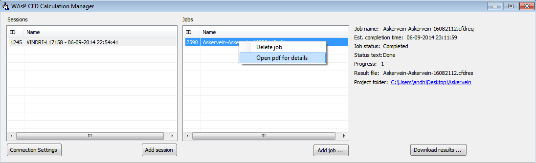
WAsP CFD calculations done after 19 August 2014 include a WAsP CFD calculation report. In order to open the report, you first download the result file using the WAsP CFD calculation manager. Once the file has been downloaded, you can right click the job and select “Open pdf for details
Description of the Report
Every WAsP CFD simulation has a unique JobID code. This code is shown on the top left of the report together with the date and time of the simulations. If it is necessary to reconstruct an old WAsP CFD calculation or ensure that results are in fact authentic WAsP CFD results, then it is possible using this code. The top right shows the used cluster, WAsP CFD and client version together with the user who requested the WAsP CFD simulation. The CPU time tells you how hard you made the cluster work.
The large table in the middle provides an overview of the 36 CFD simulations (corresponding to 36 wind directions) performed in each WAsP CFD calculation. The second column indicates if this particular CFD simulation reached the required convergence level. Since WAsP CFD always requires that all 36 CFD simulations are fully converged, it is actually not possible to get a WAsP CFD result file with non-converged results. Despite of this it can be reassuring to see it in print. Column three and four show the reached residual level (all variables are at this level or below) and the number of iterations used to reach convergence. The last two columns give the far-field roughness and terrain height; this is used to define the inflow boundary condition for the CFD simulation.
The two figures show the height contours in the inner part of the domain including the 2 by 2km WAsP CFD tile. The left figure shows the height contours directly from the request files. These are the contour lines specified by the user. The right figure shows how WAsP CFD has altered these in order to prepare them for CFD. If the user-specified contour lines do not cover the full CFD domain then WAsP CFD “estimates” the terrain height in the missing areas. Also, since the CFD simulations are done using a computational grid of finite resolution, smaller terrain features cannot be resolved and are essentially filtered out. Finally, WAsP CFD flattens the terrain in the far-field in order to have well-defined inflow boundary conditions. The contour lines on the right figure shows the terrain after it has been adapted for CFD.
The main dimensions of the computational domain and the resolution of the central part of the domain is given at bottom left of the report. The model constant used for the turbulence model is given at the bottom right.
You can see an example of a WAsP CFD Calculation Report here.